Dr. Frederick W. Vollmer
Links
Geology
American Geophysical UnionGeological Society of America
Software
AntevsEllipseFit
Orient
PicTracker
Top US Motorcycle Road List
Compiling a list of "top" motorcycle roads is an impossibly subjective task. There is an inevitable tradeoff between scenic routes, twisty technical rides, and off pavement adventures. In the motorcycle world, this basically subdivides motorcycles into cruiser, sport bike, and adventure touring categories. I ride a cruiser, and favor paved scenic routes, but enjoy the challenge of a seriously twisty road. I also generally favor destination riding, proceeding across country from place to place, rather than "clover leaf" routes based out of a specific location, just a personal preference.
During the non-riding months I seek out advice and lists compiled by other riders, to string together scenic and challenging routes for future rides. This list, however, is compiled from my own experiences riding these roads. It is not intended to be definitive in any way, it is just a compilation of my own most memorable rides. Most of these roads, outside of the northeast, I have only ridden once, and many riders have more experience on these roads than I.
I have included references to other lists of top motorcycle roads as cross references for those considering them. They are not necessarily one to one correspondences, and include overlapping segments. Gary McKechnie's 2013 book "Great American Motorcycle Tours" (GAMT-25, see below), is a particularly good reference, although I did not discover it until after completing these rides. Many online lists seem to have rides because they show up on other lists, I have tried to avoid lists that are not compiled by riders. I have also listed some eating establishments that I enjoyed at the time, these may be dated, so use your own judgement. I hope this is inspiring, enjoy your own ride!
These images are copyrighted and may not be used without permission. I specifically grant educators permission to use individual images for non-commercial use provided they are each clearly attributed, "Photograph by F.W. Vollmer".
|
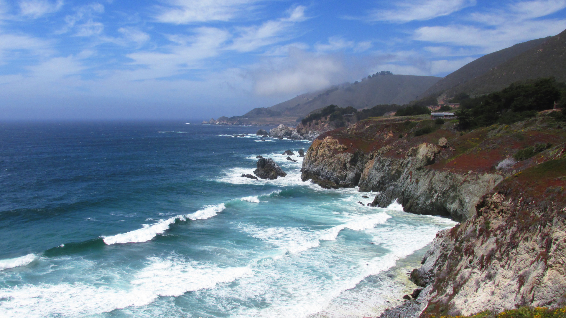
1. Pacific Coast Highway (CA 1, PCH), California. The Pacific Coast Highway stretches 656 miles (1056 km) from US 101 near Leggett CA to I-5 at Dana Point. Crossing the Golden Gate Bridge, it passes through San Francisco and Santa Cruz. For a shorter ride, the section from Carmel to Cambria (Big Sur) is perhaps the most scenic, for a longer ride, it can be linked with US 101 to the north. Beware of 15 mph corners over steep drop-offs in dense fog, and note that riding south keeps you on the cliff side! Photo: The Pacific coast in Big Sur CA. Eats: The Peg House, Leggett; Whale City Bakery Bar & Grill, Davenport; Nepenthe, Big Sur. Lists: AMA-15, BM-30, GAMT-25, LP-10, NG-10, RM-35, RRS-10. |
|
|
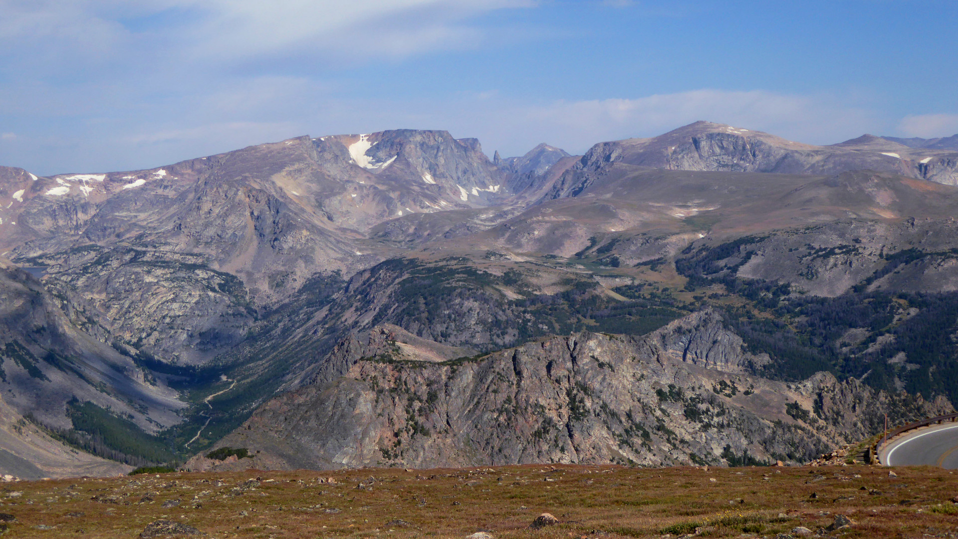
2. Beartooth Highway (US 212), Montana and Wyoming. The Beartooth Highway runs 69 miles (111 km) from Cooke City, Montana, at the NE portal of Yellowstone National Park, to Red Lodge, Montana, reaching a high point of 10,947 ft (3,337 m) at Beartooth Pass. Opened in 1936 the road can experience snow and severe weather in any season, and snow removal is not done until late in the Spring. Check road conditions before attempting. Photo: The Beartooth Mountains from Beartooth Highway. The Bears Tooth, a 11,612 foot (3,539 m) spire, is visible at center. Eats: Ore House Saloon, Cooke City. Lists: AMA-15, BM-30, DC-10, LP-10, NG-10, RM-35. |
|
|
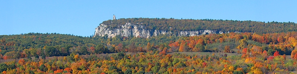
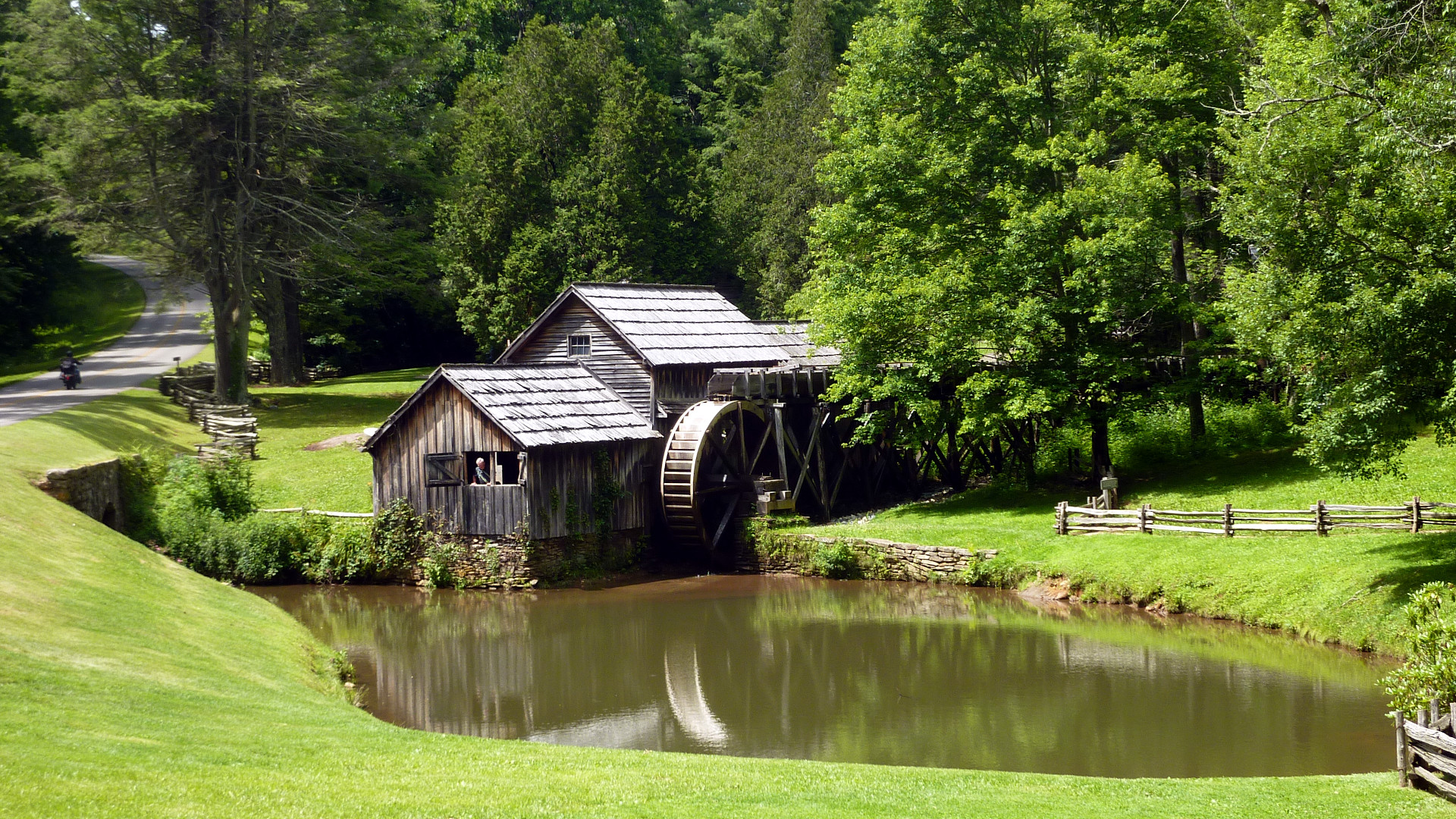
3. Blue Ridge Parkway (BRP), North Carolina and Virginia.
The Blue Ridge Parkway runs for 469 miles (755 km) through Virginia and North Carolina, mostly along the spine of the Blue Ridge of the Appalachian Mountains. The southern terminus is at Rockfish Gap VA, where it connects with Shenandoah National Park's Skyline Drive. The two-lane parkway is limited to non-commercial traffic, and is not maintained in the winter. Photo: Mabry Mill, Blue Ridge Parkway, Virginia. Lists: AMA-15, DC-10, GAMT-25, LP-10, NG-10, RM-35, RRS-10. |
|
|
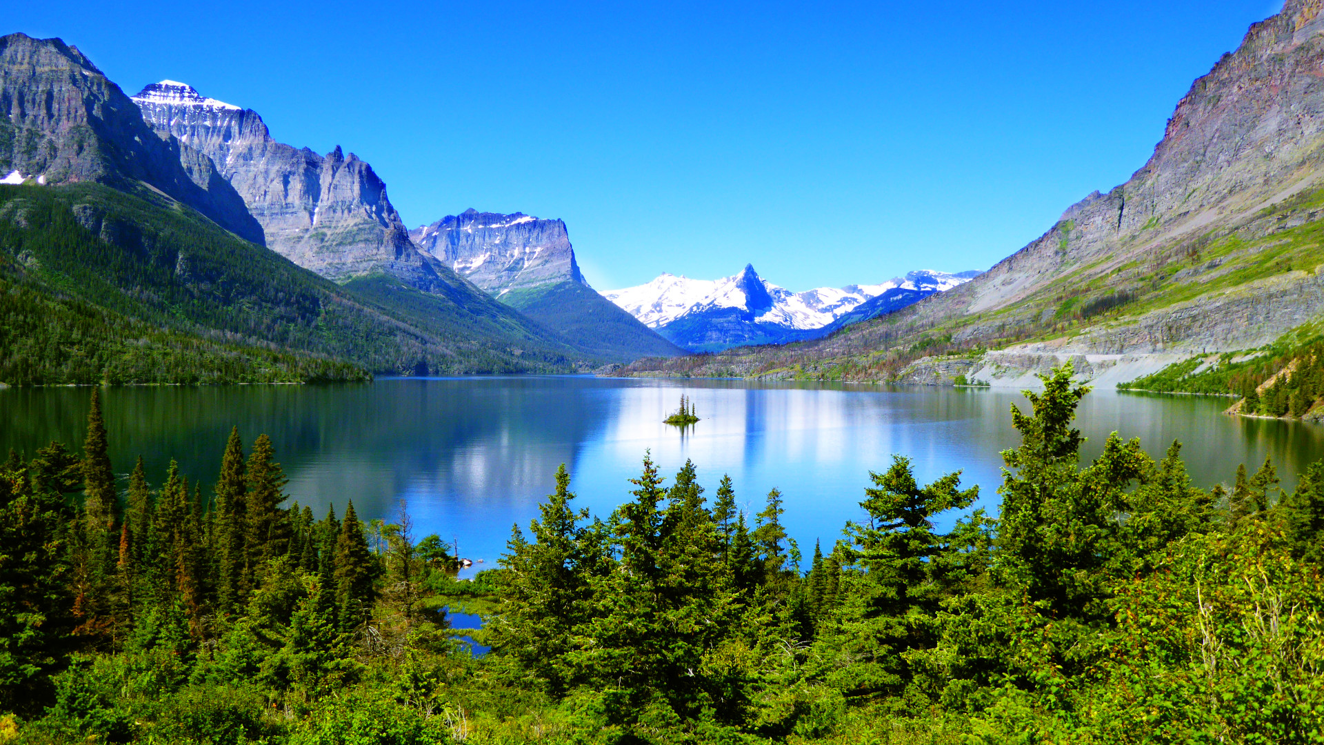
4. Going-to-the-Sun Road Glacier National Park, Montana.
Completed in 1932, the 50 mile (80 km) Going-to-the-Sun Road traverses Glacier National Park, crossing the Continental Divide through Logan Pass at an elevation of 6,646 ft (2,026 m). Heavy snow and avalanches destroy most guardrails, and the road is generally open only from June to October. Photo: Saint Mary Lake and Wild Goose Island on Going-to-the-Sun-Road, Glacier National Park, Montana. Eats: Moose's Saloon, Kalispell. Lists: AMA-15, BM-30, LP-10, NG-10, RM-35. |
|
|
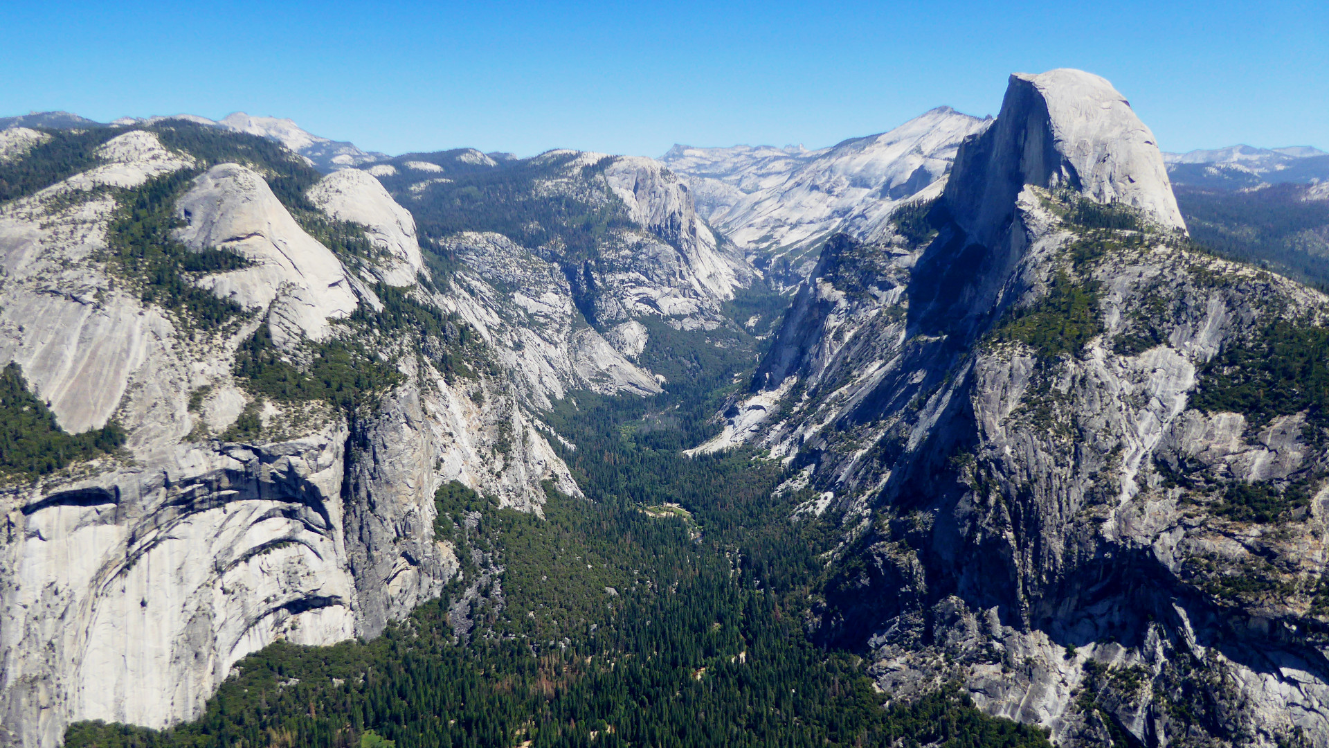
5. Yosemite National Park (CA 120 Tioga Pass Road, Glacier Point Road), California. Possibly the best known National Park in the United States, the glacially sculpted valley attracts millions of visitors each year. Most, however, spend the majority of their time on the valley floor. Even during peak season, motorcyclists can enjoy spectacular views along the Tioga and Glacier Point Roads (closed in winter). Consider riding US 395 through Owens Valley to see Mono Lake at the eastern terminus of Tioga Pass Road. Photo: Tenaya Canyon with Half Dome (right) from Glacier Point Road, Yosemite National Park, California. Eats: Whoa Nellie Deli, Lee Vining; Mammoth Brewing Co., Mammoth Lakes. Lists: GAMT-25. |
|
|
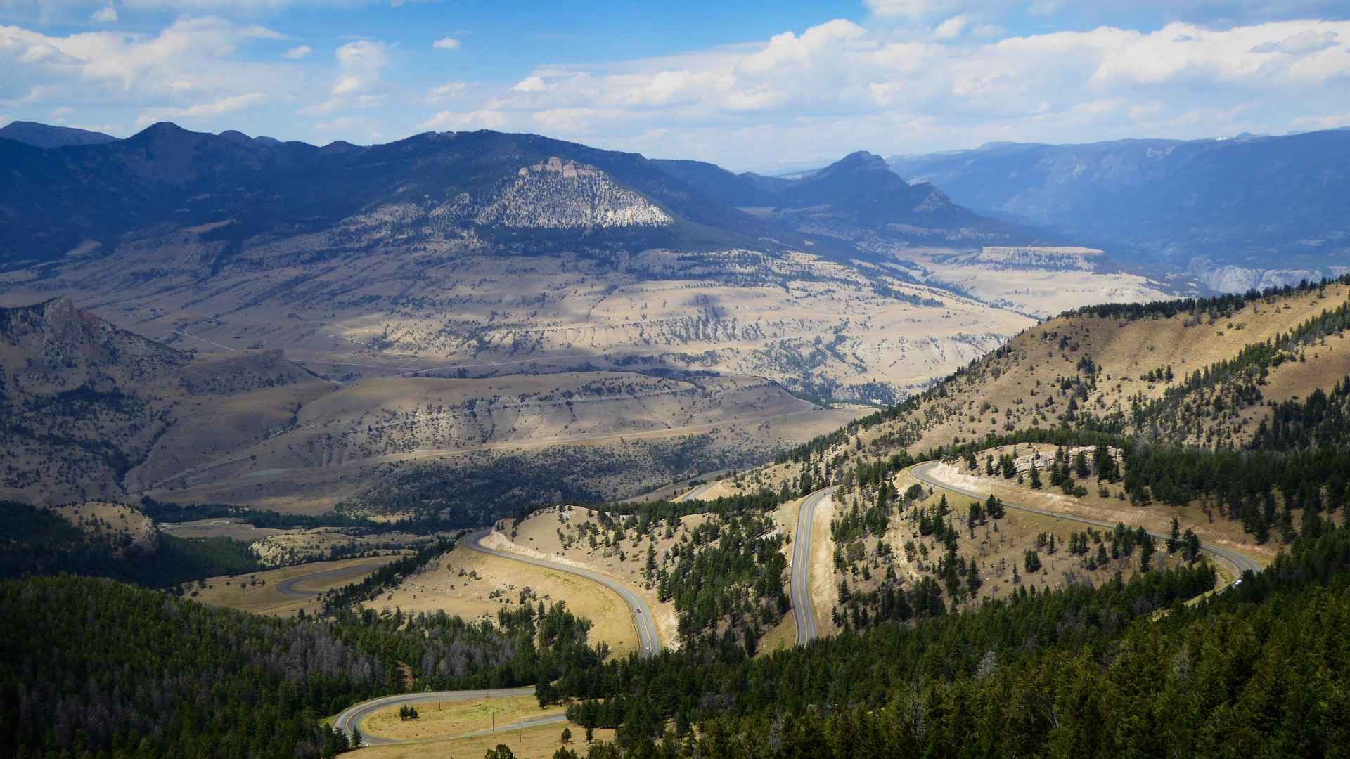
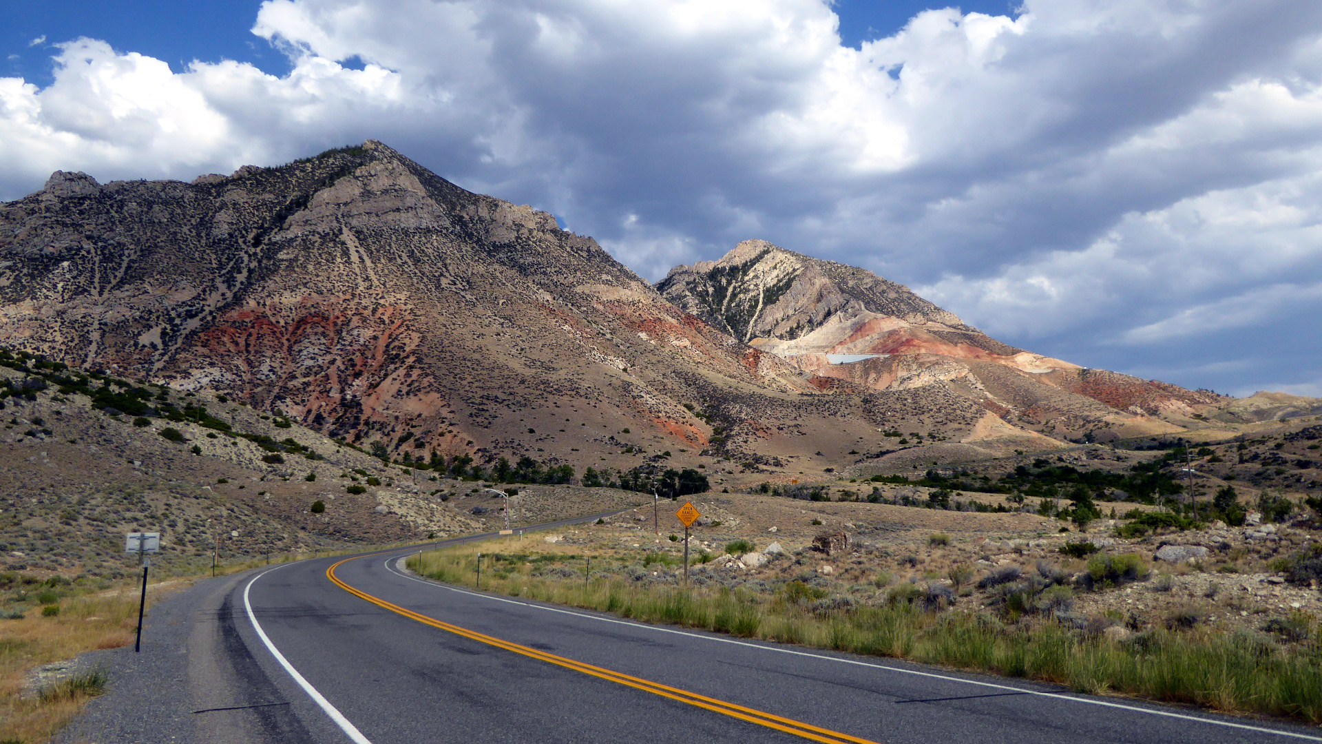
6. Chief Joseph Scenic Byway (WY 296), Wyoming. Wyoming Highway 296 is a 46 mile (74 km) scenic highway begining at US 212 (Beartooth Highway) southeast of Cooke City, Montana, passing through the Absaroka Mountains over Dead Indian Pass at 8,071 ft (2,460 m), and ending at WY 120, north of Cody. The route and pass are named in remembrance of the flight of the Nez Perce Indians during the Nez Perce War in 1877. Photo: Dead Indian Pass summit on Chief Joseph Scenic Byway, Wyoming. Lists: BM-30. |
|
|
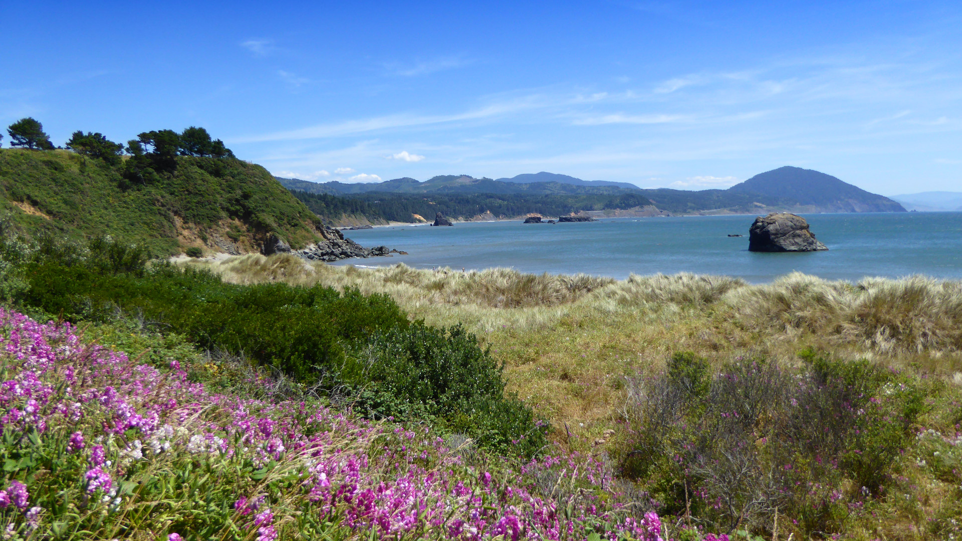
7. US 101, Washington, Oregon & Northern California. From Olympia WA, US 101 loops around the Olympic Peninsula, first north along Hood Canal, then east to Port Angeles, and Hurricane Ridge Road (5,242 ft, 1,598 m), Olympic National Park, and finally south to cross the Columbia River into Oregon at Astoria. 101 then hugs the scenic Pacific Coast to California, where it passes through Redwood National and State Parks, and meets the northern terminus of the PCH (CA 1) near Leggett, a total of 909 miles (1463 km). Photo: Pacific coast at Port Orford, Oregon. Eats: Rogue Pier 39 Public House, Astoria OR; The Peg House, Leggett CA. Lists: BM-30, GAMT-25, LP-10. |
|
|
8. The Great Northern Road (US 2). The westen segment of US 2 begins in Michigan's Upper Peninsula at the Mackinac Bridge, and extends through Wisconsin, Minnesota, North Dakota, and Montana for 1,525 miles (2,454 km) to Glacier National Park at East Glacier Village. US 2 continues on through the park, and Idaho, to Washington, however Going-to-the-Sun Road is a popular alternative. The wide open plains of North Dakota offer no shelter from high winds and frequent thunderstorms. Photo: Passing storm front on US 12, North Dakota. Lists: RM-35. |
|
|
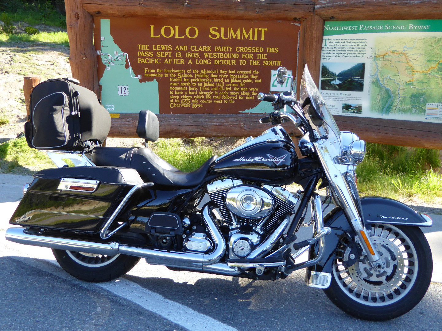
9. Northwest Passage Scenic Byway (US 12), Idaho. The 202 mile (325 km) section of US 12 passing through Idaho is known as the Northwest Passage Scenic Byway. From Lolo MT, US 12 rises steeply to Lolo Pass at 5,233 feet (1,595 m), where it enters Idaho along the historic 1805 route of the Lewis and Clark Expedition. Be warned that the speed limit drops in Idaho, and is strictly enforced. Photo: Lolo Pass summit at 5,233 ft (1,595 m) Montana/Idaho border. Lists: AMA-15, BM-30, RRS-10. |
|
|
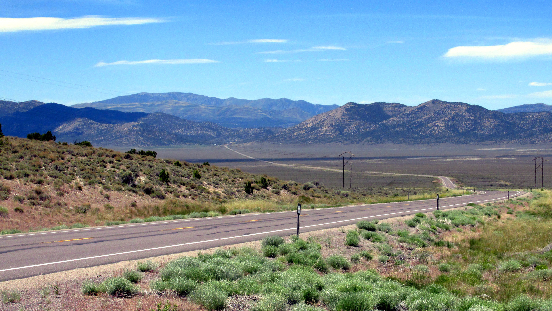
10. The Loneliest Road in America (US 50, Lincoln Highway), Nevada. From the east, US Route 50 enters Nevada near Great Basin National Park, and stretches 409 miles (658 km) west to Lake Tahoe, passing through the basin and range (graben and horst) geological province. Part of the old Lincoln Highway, it traverses 17 mountain passes up to 7,729 feet (2,356 m) in elevation, roughly following the historic Pony Express route. Watch your gas tank level, and keep an eye out for the local sheriff in Ely. Photo: Mountain pass on US 50 (Lincoln Highway), Nevada. |
|
|
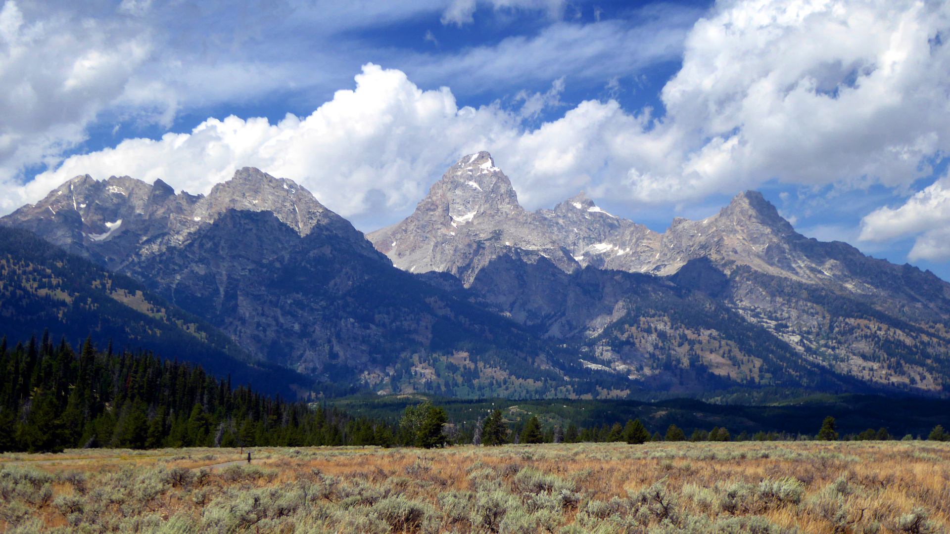
11. Twin Falls Idaho to Yellowstone National Park (US 26/191). There are numerous possible routes from the west to Yellowstone, however the route from Twin Falls is spectacular. Twin Falls boasts astounding waterfalls on the Snake River, and was the site of Evel Knievel's 1974 attempt to jump the Snake River Canyon. US 26 passes Craters of the Moon National Monument, and at Alpine, Wyoming, follows the Snake River to Hoback Junction, where it joins US 191 to Grand Teton National Park, and Yellowstone. Photo: The Teton Range, Grand Teton National Park, Wyoming. Eats: Pickle's Place, Arco, Idaho; Gun Barrel Steak & Game House, Jackson, Wyoming. Lists: GAMT-25. |
|
|
12. Yellowstone National Park to Sturgis South Dakota (US 14/14A ). The western terminus of US 14 is at the eastern entrance of Yellowstone National Park. Passing through Cody, Wyoming, it splits into US 14 and 14A, which rejoin in Bighorn National Forest. At Gillette, US 14 briefly joins I-90, then continues, with a side route (WY 24) to Devils Tower, on to Spearfish South Dakota. From Spearfish US 14A passes through Spearfish Canyon, and on to Deadwood and Sturgis. Be aware that there is no warning before the speed limit drops from 70 to 30 mph on 14A in Byron, Wyoming, you will get a ticket if going over 30. Photo: Entering the Bighorn Mountains from the west on US 14A. Eats: The Knuckle Saloon, Sturgis, South Dakota. Lists: BM-30, GAMT-25. |
|
|
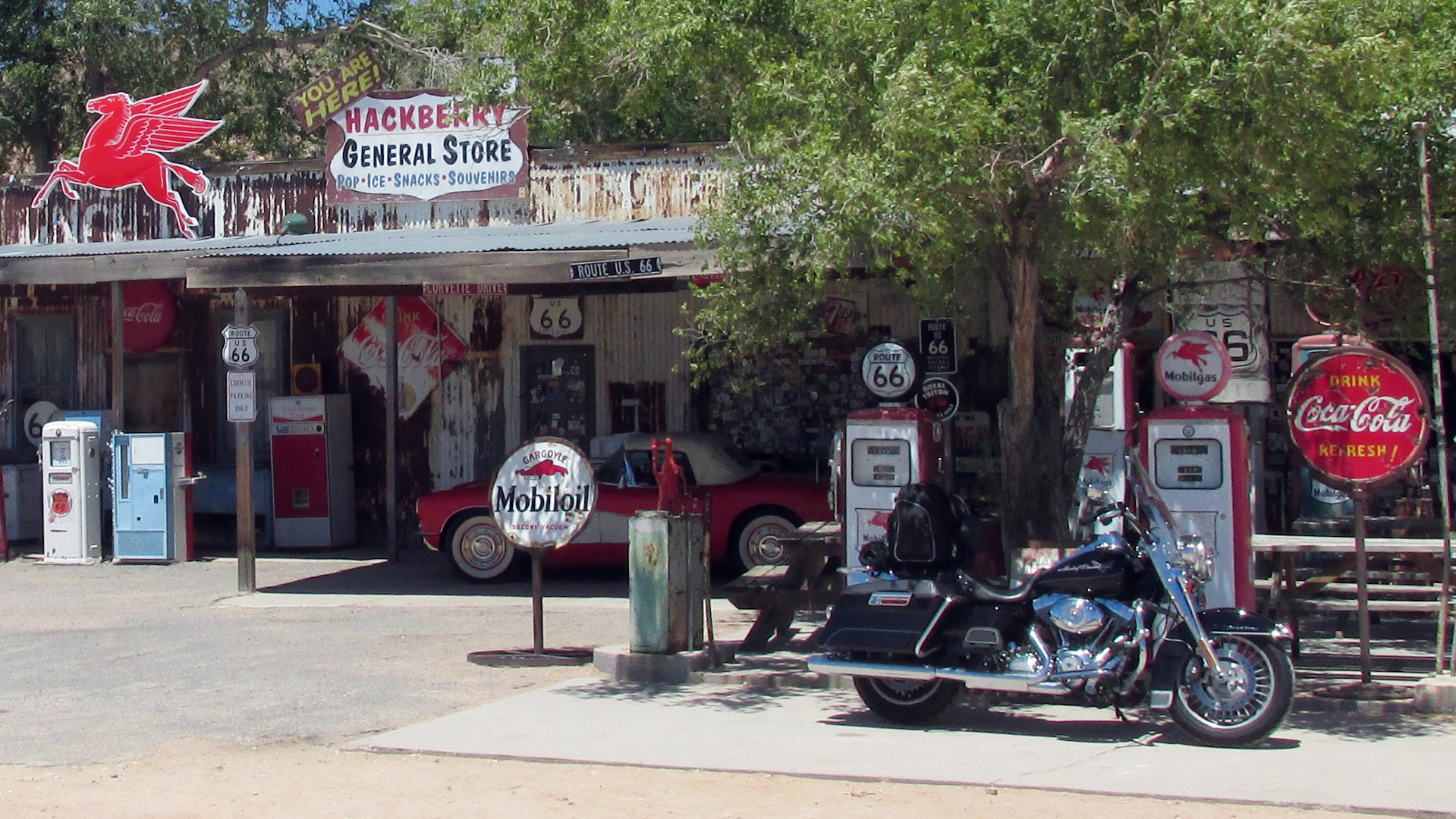
13. Route 66 (Historic US 66). Route 66, that famously "winds from Chicago to L.A., more than two thousand miles all the way", is no longer
continuous, however major portions remain for those willing to seek it out, including main streets of Barstow California, Flagstaff, Arizona, and Santa Rosa, New Mexico. The route from Kingman to Seligman in Arizona is significantly removed from I-40, and largely retains the character of the old highway. Photo: Hackberry General Store, Hackberry Arizona. Eats: La Bellavia Restaurant, Flagstaff Arizona; Beaver Street Brewery, Flagstaff AZ; Big Texan Steak Ranch, Amarillo Texas. Lists: RM-35, LP-10, RM-35. |
|
|
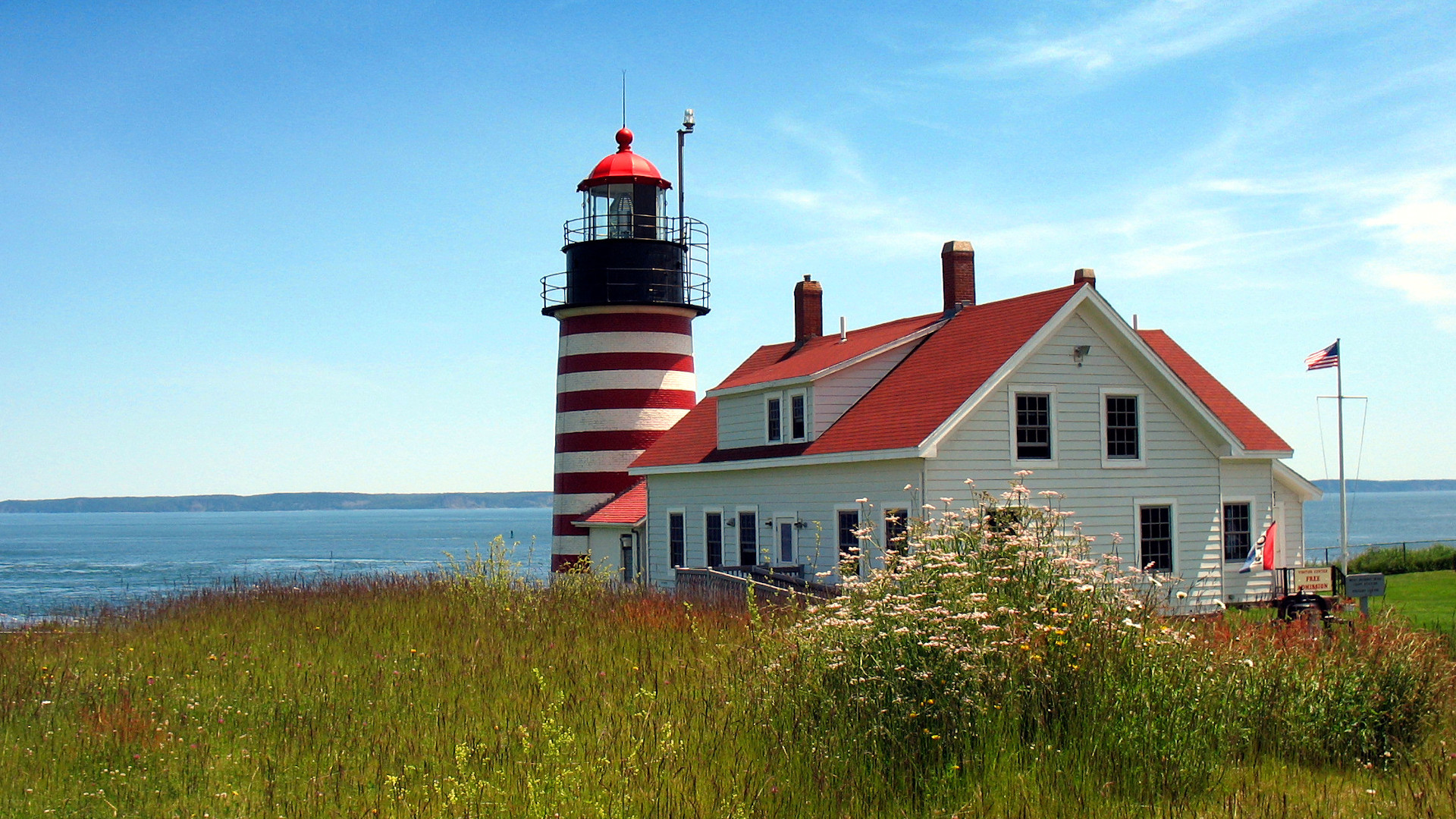
14. Coastal Route One (US 1), Maine. US 1 follows the rocky coast of Maine for 316 miles (509 km) from Kittery to Calais, and provides a scenic route to Acadia National Park. Starting at Brunswick avoids the Portland traffic, but don't pass by L.L. Bean in Freeport without stopping. Beware that the route can become clogged with RVs during the peak summer vacation season. Photo: West Quoddy Head lighthouse, Lubec Maine, the easternmost point in the contiguous United States. Eats: Red's Eats, Wiscasset, Maine; Geddy’s, Bar Harbor, Maine. Lists: BM-30, GAMT-25, LP-10, NG-10, RM-35. |
|
|
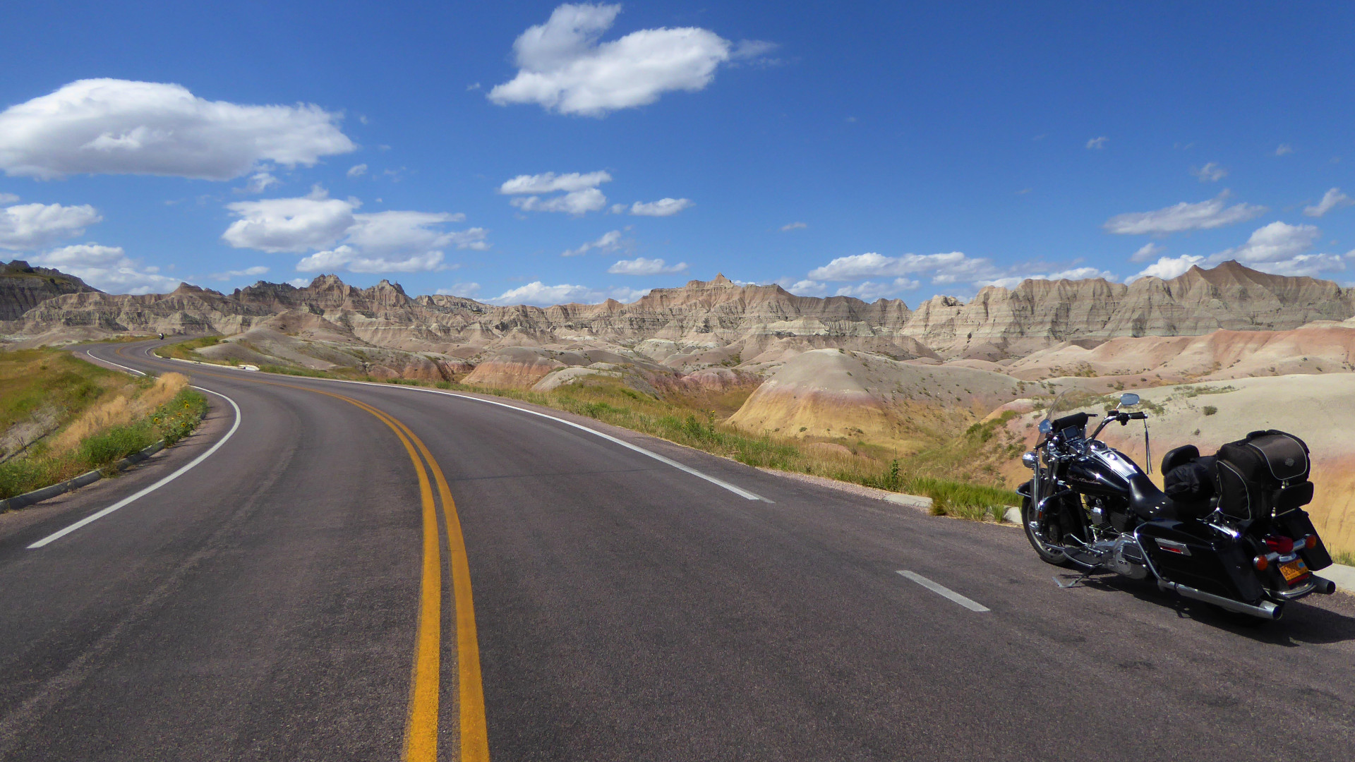
15. Badlands National Park and Nebraska Sandhills, South Dakota and Nebraska. The badlands of South Dakota are an otherworldly landscape of multicolored spires and canyons. The park loop road, SD 240, is 40 miles (64 km) long, but a longer ride can be had by taking SD 44. Wall Drug, in Wall, South Dakota, a sprawling tourist attraction that draws over a million annual visitors, is worth a visit. Head south on US 83 to intersect with US 20, which passes through the Nebraska Sandhills, the largest sand dune complex in the western hemisphere. US 20 follows the northern reaches. Don't miss the Ashfall Fossil Beds exposures of fossil mammals trapped in a Yellowstone eruption 12 million years ago. Photo: Badlands National Park, South Dakota. Eats: Wall Drug, Wall, South Dakota. |
|
|
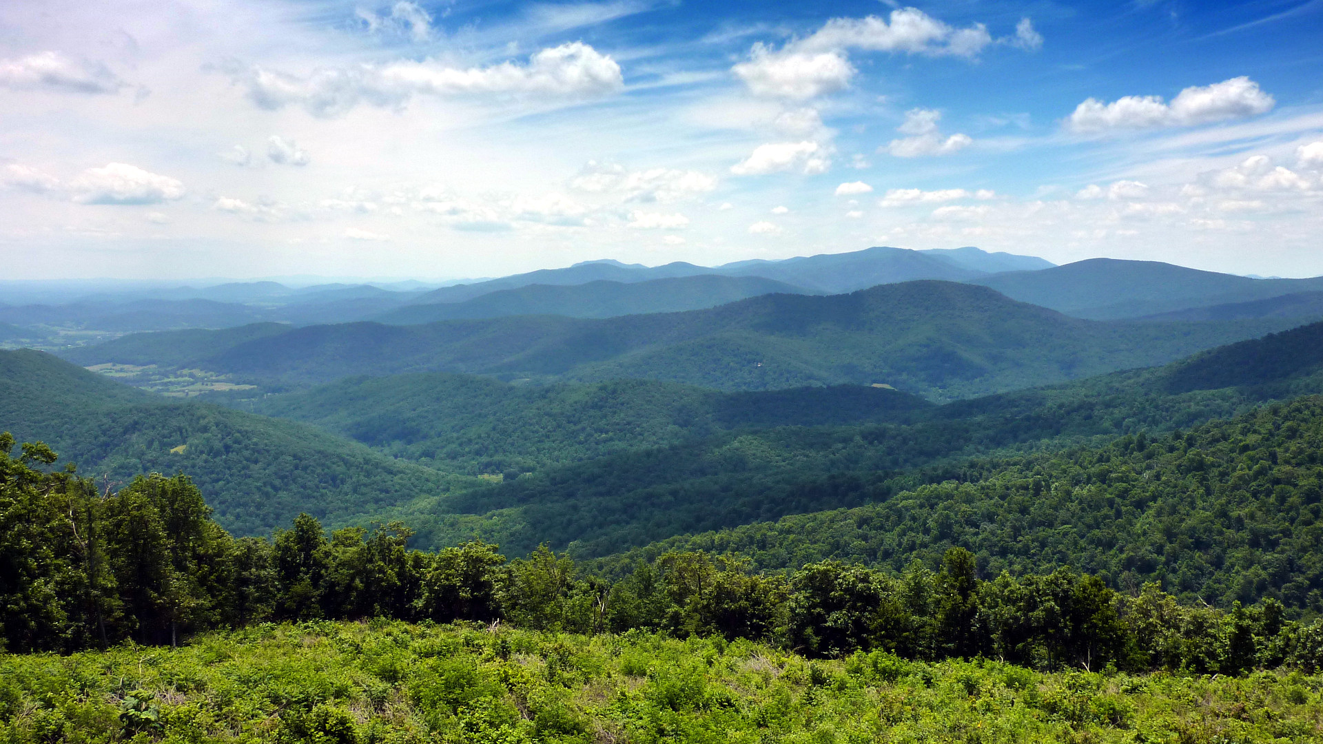
16. Skyline Drive, Virginia. Skyline Drive follows the crest of the Blue Ridge Mountains for 105 miles (169 km) through Shenandoah National Park. Its southern terminus at Rockfish Gap Virginia, connects to the Blue Ridge Parkway. Geologically, the Blue Ridge is an exposed thrust sheet of ancient basement rocks that are resistant to erosion, forming a prominent mountain ridge. Photo: Blue Ridge Mountains from Skyline Drive, Shenandoah National Park. Lists: LP-10, NG-10. |
|
|
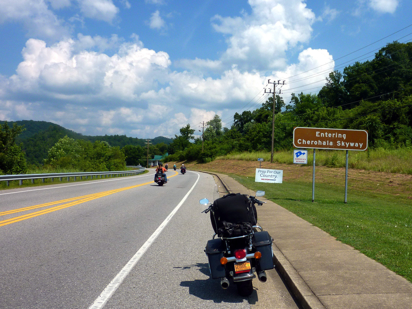
17. Cherohala Skyway, North Carolina and Tennessee. The Cherohala Skyway is a 43-mile (69 km) National Scenic Byway connecting Tellico Plains, Tennessee, to Robbinsville, North Carolina, passing through the Cherokee and Nantahala National Forests, hence the name "Cherohala". Planning for the road began in 1958, but the road was not completed until 1996 at a cost of about 100 million dollars. Photo: Western entrance of the Cherohala Skyway at Tellico Plains, Tennessee. Lists: AMA-15, BM-30, DC-10, LP-10, RRS-10. |
|
|
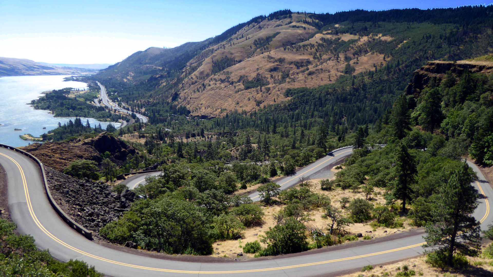
18. Columbia River Highway (Historic US 30), Oregon. Completed in 1922, the 75 mile (121 km) Columbia River Highway was one of the first modern paved highways in the Pacific Northwest. Now dissected by I-84 into four segments, it is well worth the trouble to follow the preserved historic sections. Photo: The "Rowena Loops" on Columbia River Highway (Historic US 30) Oregon at Rowena Crest. Eats: Clock Tower Ales, The Dalles, Oregon. Lists: RM-35, RRS-10. |
|
|
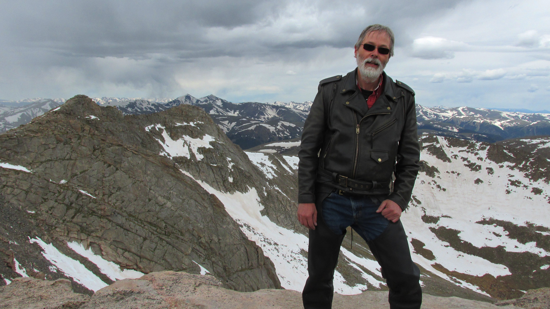
19. Mount Evans Scenic Byway, Colorado. The Mount Evans Scenic Byway, Colorado, is the highest paved road in North America. From Idaho Springs, Colorado, it follows CO 103 and CO 5 for 28 miles (45 km) to 14,130 feet (4,310 m), where a short hike leads to the summit at 14,271 feet (4,350 m). The section on CO 5 is narrow with steep drop-offs without guardrails, and is closed in winter. Photo: The summit of Mount Evans, 14,271 feet (4,350 m). Eats: Echo Lake Lodge, Colorado. |
|
|
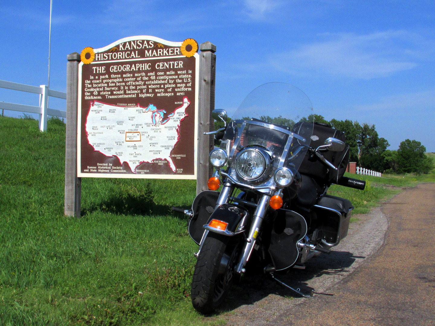
20. US 36, Ohio to Colorado. US 36 stretches 1,414 miles (2,276 km) from Ohio to Colorado. West of Indianapolis, Indiana, the road crosses the Mississippi River at Hannibal, Missouri, former home of author Mark Twain, follows the Pony Express Highway, passes through farmlands and small towns, and the geographic center of the contiguous United States. The High Plains region of western Kansas and eastern Colorado is remote, be sure to top off your gas tank at every chance. Photo: Geographic center of the contiguous United States, near Lebanon, Kansas. Eats: Las Canteras, Smith Center, Kansas. Lists: RM-35. |
|
|
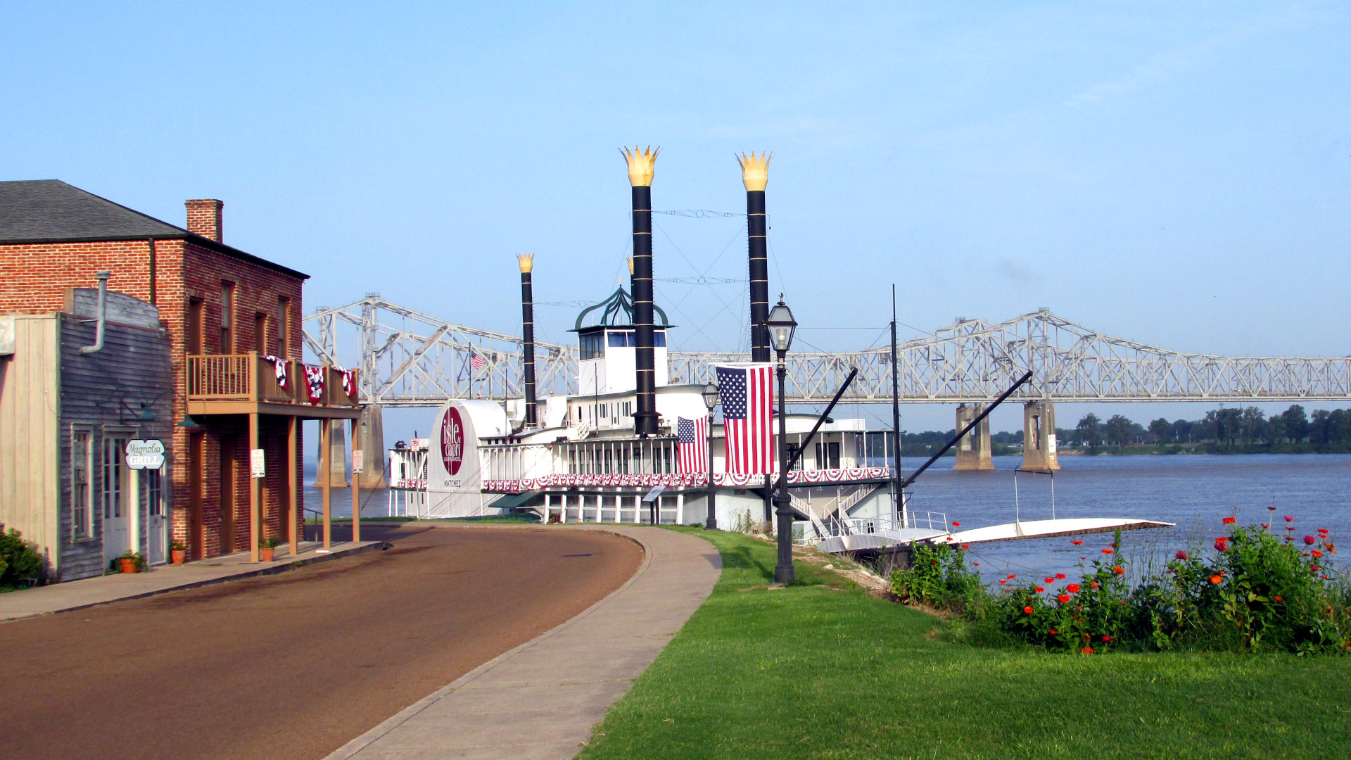
21. Natchez Trace Parkway, Tennessee, Alabama, and Mississippi. The Natchez Trace Parkway is a limited access two lane road that extends 444 miles (715 km) from Natchez, Mississippi, to Nashville, Tennessee. It follows the historic "Old Natchez Trace", used by native Americans, and later by traders and travelers. In the early 1800s, river-men ran flatboats down the river, delivered goods to Natchez, and returned to Nashville along the dangerous Trace. Photo: Natchez Under-The-Hill, Mississippi, formerly a notorious port on the Mississippi River. Lists: AMA-15, NG-10, RM-35. |
|
|
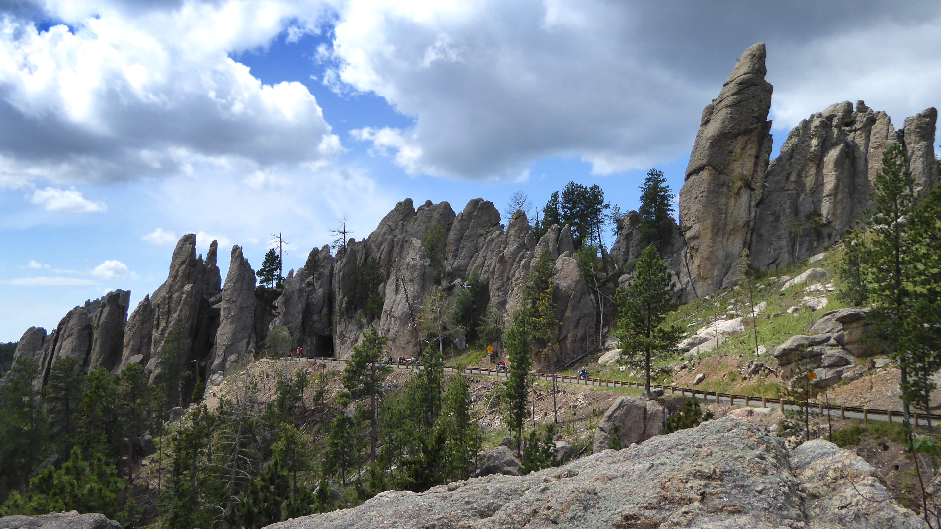
22. Needles Highway, Peter Norbeck Scenic Byway, South Dakota. The Peter Norbeck Scenic Byway in South Dakota includes portions of US 16/16A, and SD 244/87/89, much of which is carved into bedrock granite. Needles Highway is a segment on SD 87, and the Iron Mountain Road is a segment along US 16A. Bison graze in Custer State Park, and Mount Rushmore and the Crazy Horse Memorial are popular side trips. Note that the area fills with thousands of bikers during the annual Sturgis Rally. Photo: Needles Eye Tunnel, Needles Highway, South Dakota. Eats: The Knuckle Saloon, Sturgis SD. Lists: BM-30, DC-10, GAMT-25, RM-35, RRS-10. |
|
|
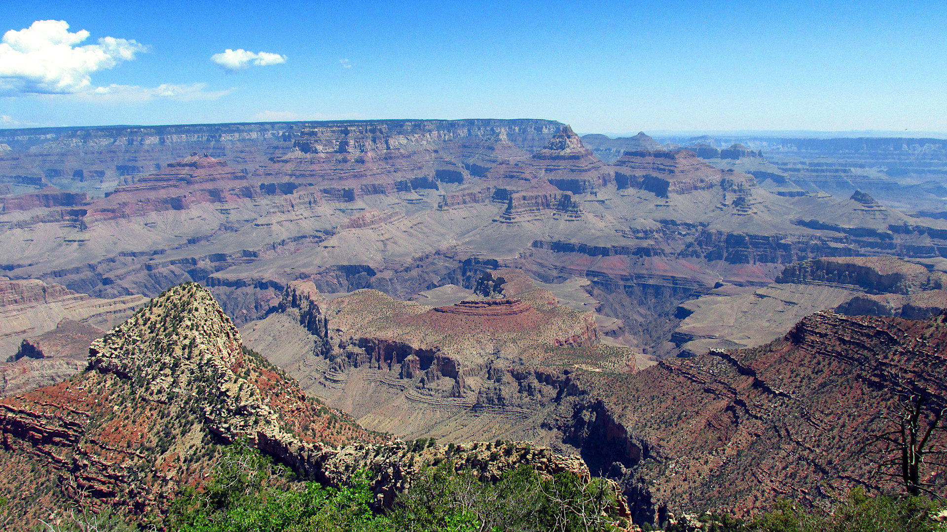
23. Sedona to the Grand Canyon of the Colorado, Arizona. AZ 89A is an 84 mile (135 km) state highway within Cocinino National Forest that runs from Prescott, Arizona, north to Flagstaff, passing through Jerome, Cottonwood, and Sedona. The section near Sedona is known for its scenic beauty, and has been used as a film location for many movies. From Jerome back to Flagstaff, a splendid loop is to pass Mormon Lake following AZ 260/87/3. From Flagstaff US 89 and AZ 64 head north to the Grand Canyon of the Colorado. The road is less interesting, but the destination is spectacular. Photo: The Grand Canyon of the Colorado, from Desert View. Eats: Bobby D's BBQ, Jerome, Arizona. Lists: GAMT-25. |
|
|
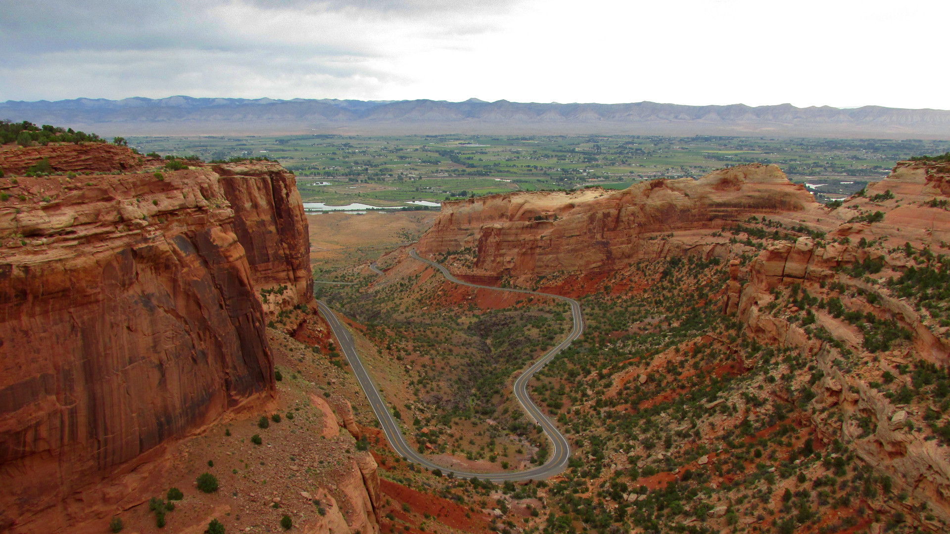
24. Rim Rock Drive, Colorado National Monument, Colorado. Rim Rock Drive is a scenic 23 mile (37 km) road that follows the upper rim of a series of dramatic sandstone canyons from near Fruita, Colorado to near Grand Junction, Colorado. The road was constructed mostly by manual labor as a Depression Era Works Progress Administration project, and is on the National Register of Historic Places. Photo: Fruita Canyon, Rim Rock Drive, Colorado National Monument, Colorado. Eats: Hot Tomato Cafe, Fruita, Colorado; Copper Club Tap Room, Fruita, Colorado. |
|
|
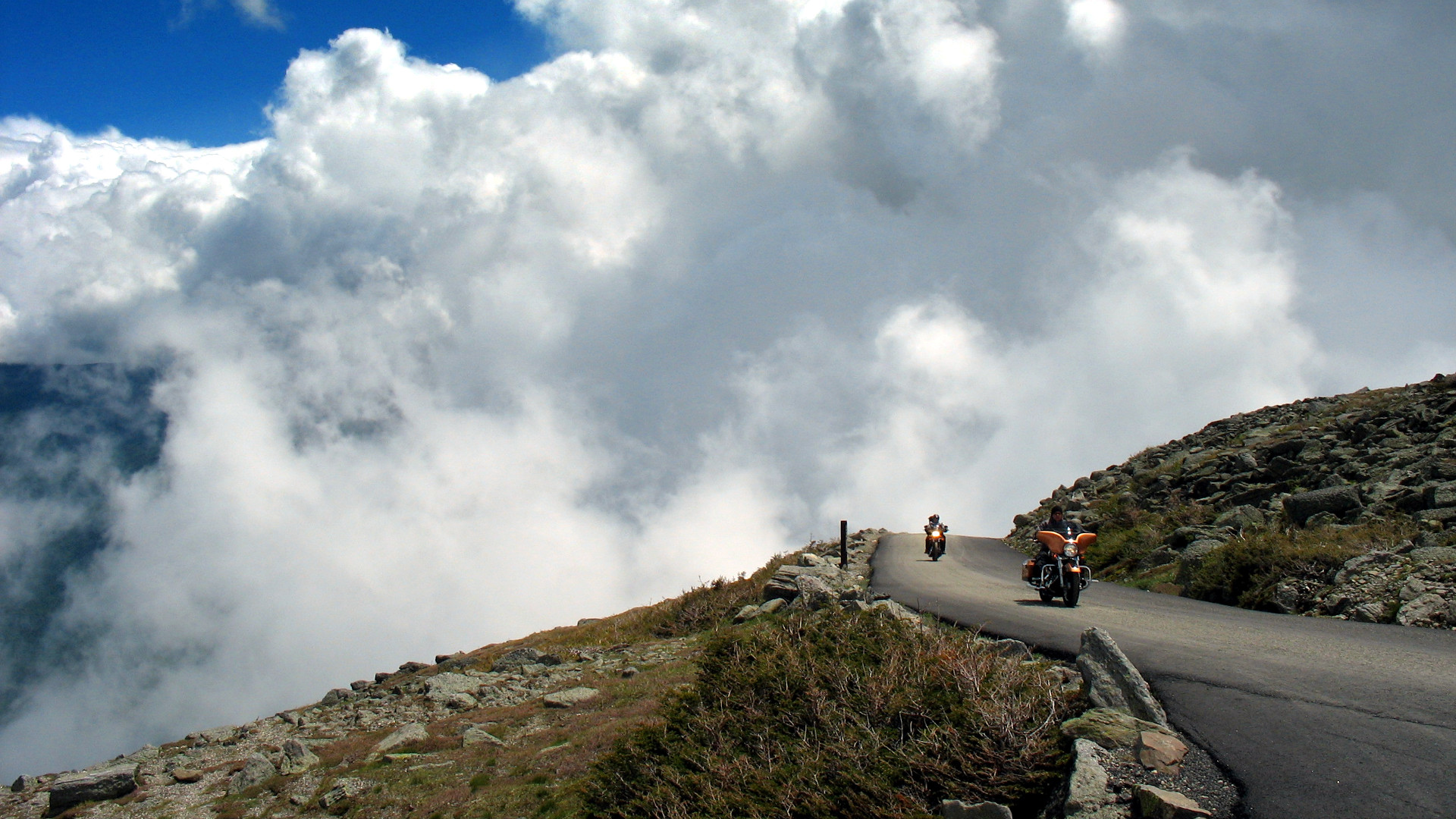
25. Mount Washington Auto Road and the White Mountains, New Hampshire. An essential loop in the White Mountains follows I93 through Fraconia Notch State Park, NH 112 (the Kancamagus Highway), and US 302, with a side trip up the Mount Washington Auto Road. The road, opened in 1861, is a 8 mile (12 km) toll road that extends from NH 16 to the summit. It gains 4,618 ft (1,408 m) to 6,145 ft (1,873 m), has no guardrails, and has a short unpaved section. The mountain is notorious for bad weather, with some of the highest recorded winds in the world. On the annual “Ride to the Sky” during Laconia Motorcycle Week, the road is open only to motorcycles. Photo: Mount Washington Auto Road, New Hampshire. Eats: Sea Dog Brew Pub, Conway, New Hampshire. Lists: RM-35. |
|
|
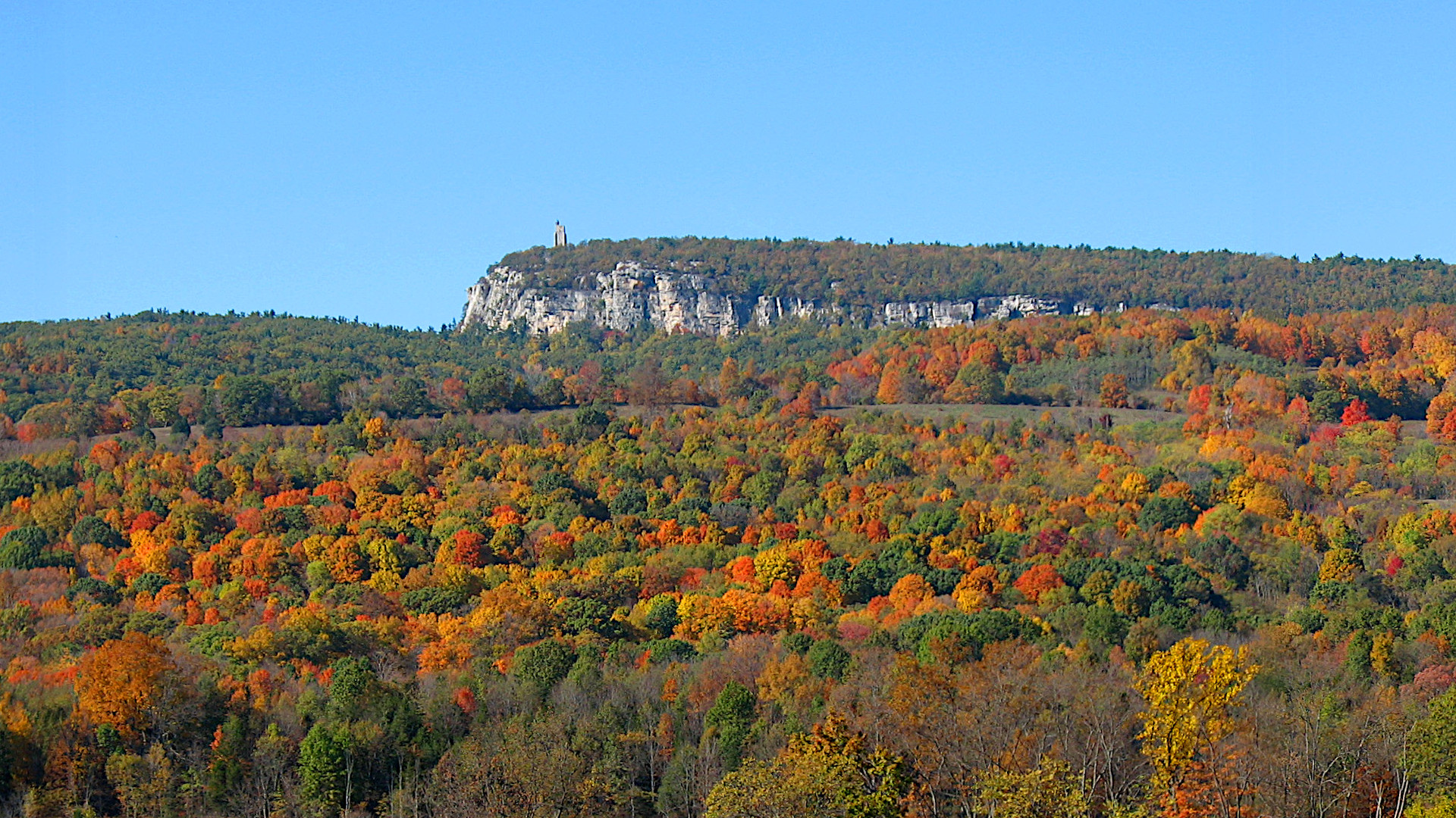
26a. Hudson Valley, Catskill and Adirondack Mountains, New York. New York State is associated with New York City in the minds of many, but "upstate" New York has scenic roads in spades. This route is somewhat complicated, but is worth the effort. From New Paltz follow NY 299 and US 44 west over Shawangunk Ridge, then US 209 north to Kingston. In Kingston follow US 32 north to Palenville, then NY 23A west up Kaaterskill Clove. At Grand Gorge take NY 30 181 miles (291 km) north into the Adirondack Mountains. Take the junctions with NY 3 and NY 86 to Lake Placid, and then NY 73 and NY 9N through Elizabethtown to NY 22 at Westport. NY 22 continues south 180 miles (290 km) to reconnect with US 44. An alternative is to take US 4 at Whitehall south through Troy. Note that during the annual Americade motorcycle rally, thousands of other bikers will share the road. Photo: The Shawangunk Ridge, New Paltz, New York. Eats: Huckleberry, New Paltz; Rough Cut Brewing, Kerhonkson; Keegan Ales, Kingston; Lake Placid Pub & Brewery, Lake Placid; Dinosaur Bar-B-Que, Troy. Lists: BM-30. |
|
|
26b. Hudson Valley, and Catskill Mountains, New York. This is a less ambitious, 109 mile, tour connecting picturesque towns of the Hudson Valley and Catskill Mountains, easily accessed by I87, and giving plenty of time for sightseeing and a meal. From New Paltz follow NY 299 and US 44 west over the Shawangunk Ridge, then follow US 209 north to Kingston. In Kingston take the roundabout to follow US 32 through Saugerties north to Palenville, then NY 23A west up Kaaterskill Clove. Just west of Tannersville, follow 214 southwest to Phonecia. Make a left in Phonecia, to follow the Mt. Tremper-Phonecia Road south to 212. Take another left and follow 212 to Woodstock. Leaving Woodstock follow signs heading south to Route 28. At Route 28 make a right, following it to Shokan, then make a left to cross the Ashokan weir with views of Slide Mountain. After crossing the weir, follow 28A left to the northeast, making sure to catch a quick left on Dike Road for additional views. A left at the next intersection leads to Route 28, and a right follows 28 back to the Kingston roundabout and I87. Photo: The Shawangunk Ridge, New Paltz, New York. Eats: Huckleberry, New Paltz; Rough Cut Brewing, Kerhonkson; Miss Lucy's, Saugerties; Sweet Sue's, Brio’s Pizzeria, Phonecia; Bread Alone, Woodstock; Hickory BBQ, Route 28; Keegan Ales, Mariner's Harbor, Ship to Shore, Sunrise Bagel, Kingston. Other: Woodstock Harley-Davidson, Route 28. |
|
|
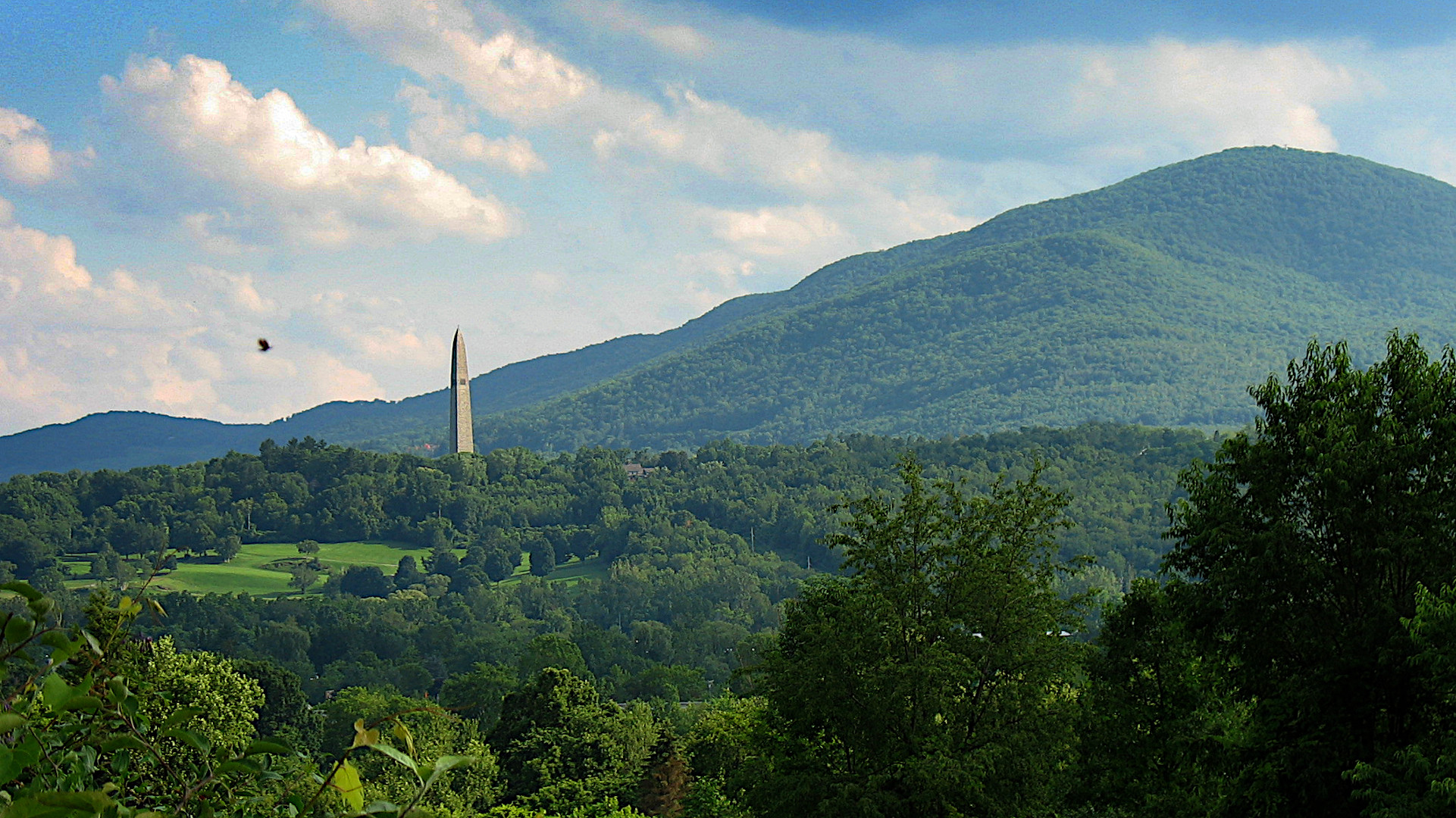
27. The Berkshire and Green Mountains (US 7/7A, VT 100), Connecticut, Massachusetts, and Vermont. US 7/7A is a 308 mile (496 km) road beginning in Connecticut that follows the Housatonic River and Berkshire Mountains north through Massachusetts, and into the Green Mountains of Vermont. VT 100 runs north for 217 miles (349 km) from the Massachusetts state line to VT 105 near the Canadian border. It passes along the eastern edge of the Green Mountain National Forest, through ski and resort towns. The roads may be linked near Manchester, or done as a loop. Side trips include the Green Mountain passes, such as Smugglers Notch (VT 108), the Equinox Skyline Drive, and the Mount Greylock summit road.
Photo: Bennington Battle Monument, Bennington, Vermont. Eats: McGrath's Irish Pub at the Inn at Long Trail, Killington, VT. Lists: BM-30, GAMT-25, RM-35. |
|
|
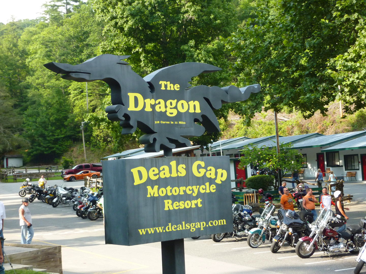
28. Tail of the Dragon (US 129), Deal's Gap, Tennessee. "318 curves in 11 miles", the 11 mile (18 km) stretch of US 129 referred to as the Tail of the Dragon is an internationally famous destination for motorcyclists. Unfortunately, this means that there is a near constant stream of motorcycles and sports cars riding the narrow twisty two lane road. Concentration is essential, and, even at a good clip, a sport bike rider may pass you on the double yellow dragging a knee. It is an exhilarating must do ride, but be warned that accidents are common. Photo: Deals Gap Motorcycle Resort, North Carolina, at the top of the Dragon. Eats: Burgermaster Drive-In, Townsend, Tennessee. Lists: AMA-15, BM-30, DC-10, GAMT-25, NG-10. |
|
|
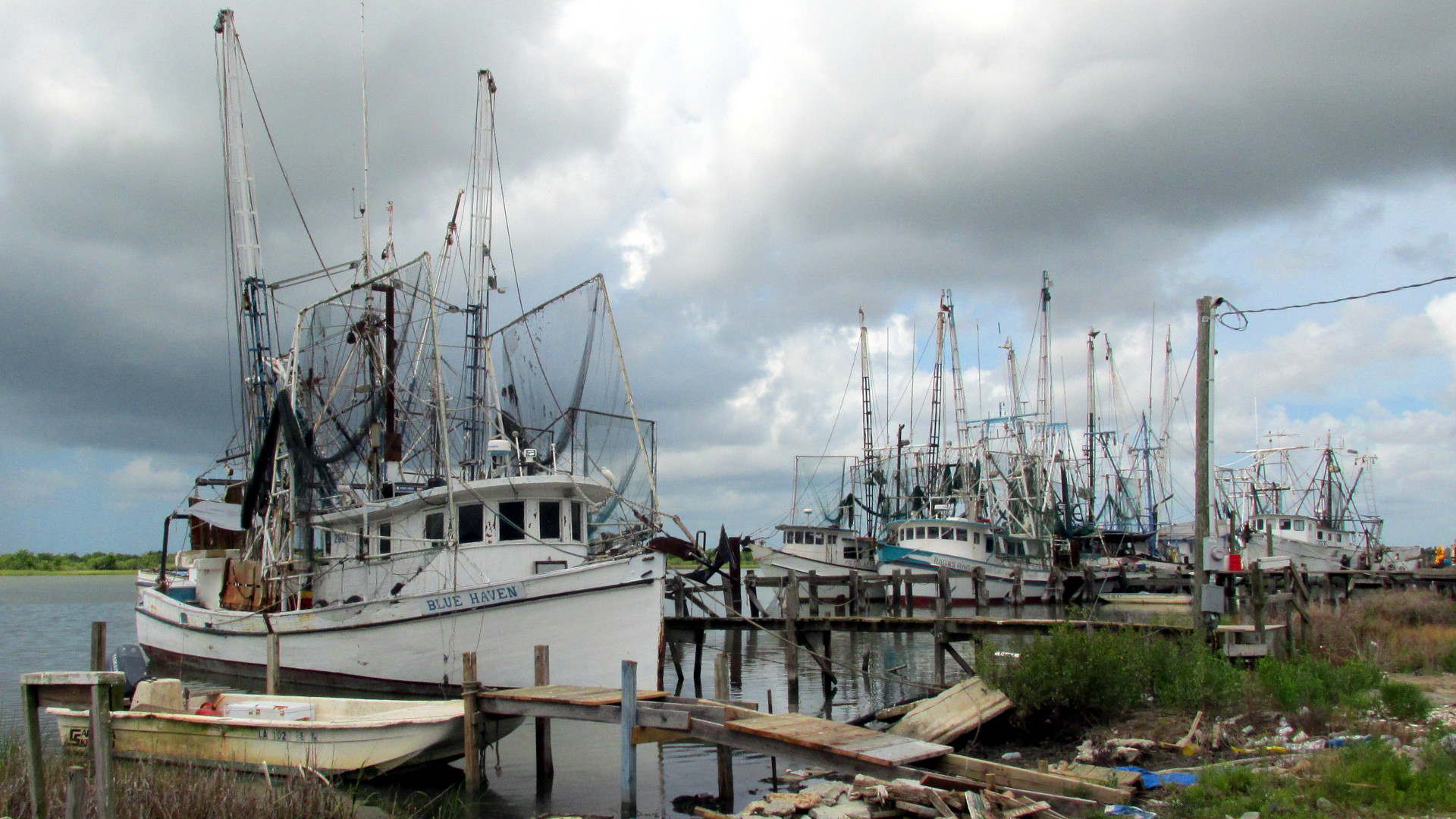
29. Creole Nature Trail, Louisiana. The Creole Nature Trail, a 180 mile (290 km) National Scenic Byway in Calcasieu and Cameron Parishes, Louisiana, offers glimpses of “Louisiana's Outback”, winding through coastal marshes and wildlife refuges, and along the Gulf Coast. Cameron Parish has been severely damaged by several hurricanes, notably Rita in 2005 and Ike in 2008, and has not fully recovered. A short ferry crossing is required, and keep an eye out for alligators crossing the road. If continuing east, check out Avery Island, the home of Tabasco sauce. Photo: Shrimp boats, Cameron Parish, Lousiana. |
|
|
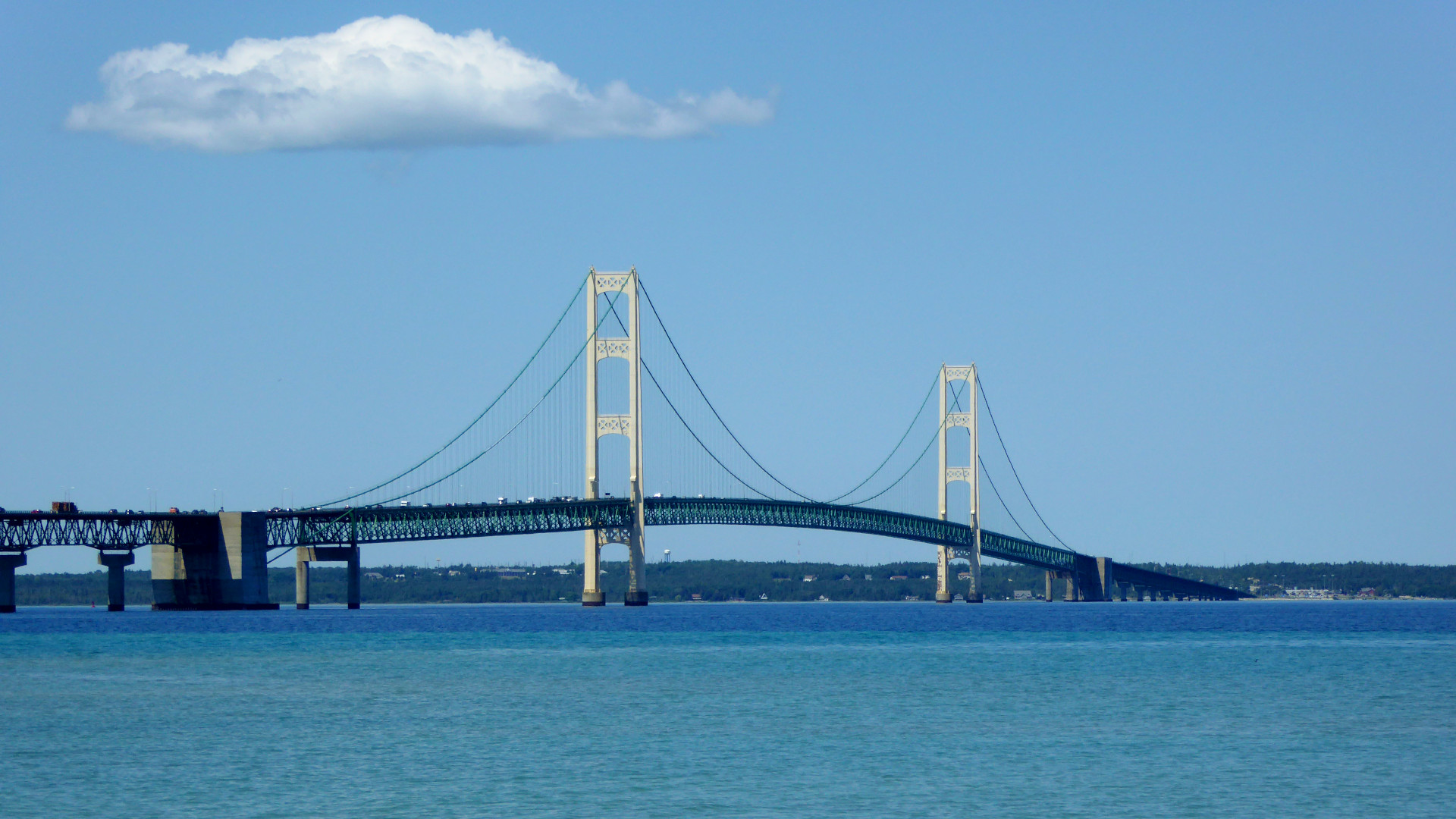
30. Lake Michigan Coast (US 31/MI 119), Michigan. Western Michigan has spectacular scenic roads along its Lake Michigan coast. The section from Traverse City to Mackinaw City hugs the coastline, leading to the 26,372 foot (8,038 m) long Mackinac Bridge, opened in 1957, that crosses to Michigan's Upper Peninsula. MI 119 passes through the Tunnel of Trees, a scenic, if highly trafficked, route through dense foliage. Be sure to sample the local walleye. Photo: The Mackinac Bridge, from Mackinaw City, Michigan. Eats: Northern Peaks Brewery, Traverse City, Michigan. Lists: DC-10, GAMT-25. |
|
|
Top US Motorcycle Roads Lists Consulted AMA-15 = AMA America's 15 Best Motorcycling Roads (AMA members, 2011). BM-30 = The American Classics: 30 Classic American Motorcycle Rides (Butler Maps). DC-10 = Discovery Channel's Top 10 Motorcycle Rides in North America (2016). GAMT-25 = Great American Motorcycle Tours, 5th Edition (Gary McKechnie, 2013). LP-10 = Lonely Planet The USA's 10 best motorcycle roads (Carla King, 2019). NG-10 = National Geographic Top 10 Motorcycle Rides in the U.S. (2015). RM-35 = Rider Magazine 35 Bucket-List Motorcycle Rides (Clement Salvadori, 2015). RRS-10 = RoadRUNNER’s Top 10 Scenic Rides in the U.S. (Jim Parks, 2013). |
|
Updated 11 Jun 2022
F.W. Vollmer © 2019-2022
